Railinc rolled out a new RIGIS Routing + Mileage application, the central repository for North American railroad spatial locations and accurate mileage data on the railroad network. This centralized system provides regulatory, financial settlement, and safety benefits for stakeholders, including shippers, car owners, railroads, and local first responders.
“This is a new standard for industry location identification and mileage calculations,” says Brent Kastor, senior GIS manager, Railinc.
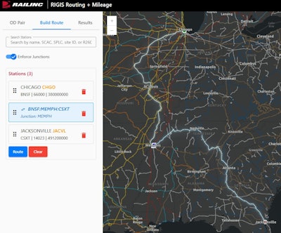
Key takeaways:
· With its unique routing and mileage tool, RIGIS allows users to visualize and analyze routes with a high degree of accuracy. When an origin and destination are entered, the application displays the carriers involved and breaks down the mileage by state. Users can refine results by selecting preferred carriers or build their own routes with multiple network locations, including the ability to require junctions at specific interchange locations. The underlying API is highly scalable and highly available, ensuring reliable performance under heavy loads.
· The project is a partnership between the Association of American Railroads (AAR) GIS Committee participants and Railinc.
· This new routing capability also strengthens industry data quality and ensures consistency in mileage calculations. This solution simplifies system integration, reduces cost and redundancy for railroads, and allows any user—via the API—to incorporate open-source route visualizations into their own mapping applications.